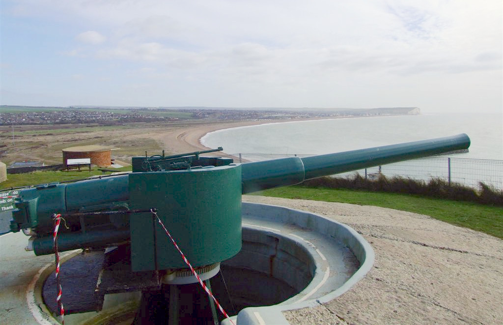
The
Fort, gun emplacement at Newhaven.
Newhaven is a port town in the Lewes district of East
Sussex, England, lying at the mouth of the River Ouse.
This is another location that Jimmy
has visited a number of times with his mother and father; Timothy
and Marion.
Jimmy's favourite area was the Tide Mills, and marshes where he caught
many tadpoles. He also like the marina and harbour area, watching the
boats coming and going. Then there was the fish and chips. Mmmmmm.
The town developed during the Middle Ages as the nearby port of Seaford began drying up, forcing a new port to be established. A sheltered harbour was built in the mid-16th century, and a breakwater in the late 18th, to provide continued access to the sea. Newhaven increased in importance following the arrival of the railway in 1847, and regular cross-Channel ferry services to Dieppe. Though these have been reduced in the 21st century, Newhaven still provides regular ferry services and continues to be used as an important freight terminal. In 2021 the parish had a population of 12,854.
ORIGINS
Newhaven lies at the mouth of the River Ouse, in the valley the river has cut through the South Downs. Over the centuries the river has migrated between Newhaven and Seaford in response to the growth and decay of a shingle spit (shoal) at its mouth.
There was a Bronze Age fort on what is now Castle Hill.
In about 480 AD, the Saxon people established a village near where Newhaven now stands, which they named "Meeching" (variously known as "Myching" or "Mitching").
Throughout the Middle Ages, the main outlet and port of the Ouse was at Seaford (one of the Cinque Ports).
The growth of the shingle spit hindered the outflow of the river, which consequently flooded the Levels upstream and hindered access to the port. Therefore, a channel through the shingle spit was cut in the mid-16th century below Castle Hill, creating access to a sheltered harbour, better than that at Seaford. This was the origin of modern Newhaven.
However, shingle continued to accumulate and so the mouth of the Ouse began to migrate eastwards again. Under the Ouse Navigation Act (1790), a western breakwater was constructed to arrest longshore drift and so cut off the supply of shingle to the spit. A new outlet (The Cut) was built on the river's present course, below Castle Hill. At that time the settlement began to be known as the "new haven". The present breakwater was built in 1890.
It was part of the Holmstrow hundred until the abolition of hundreds in the 19th century.
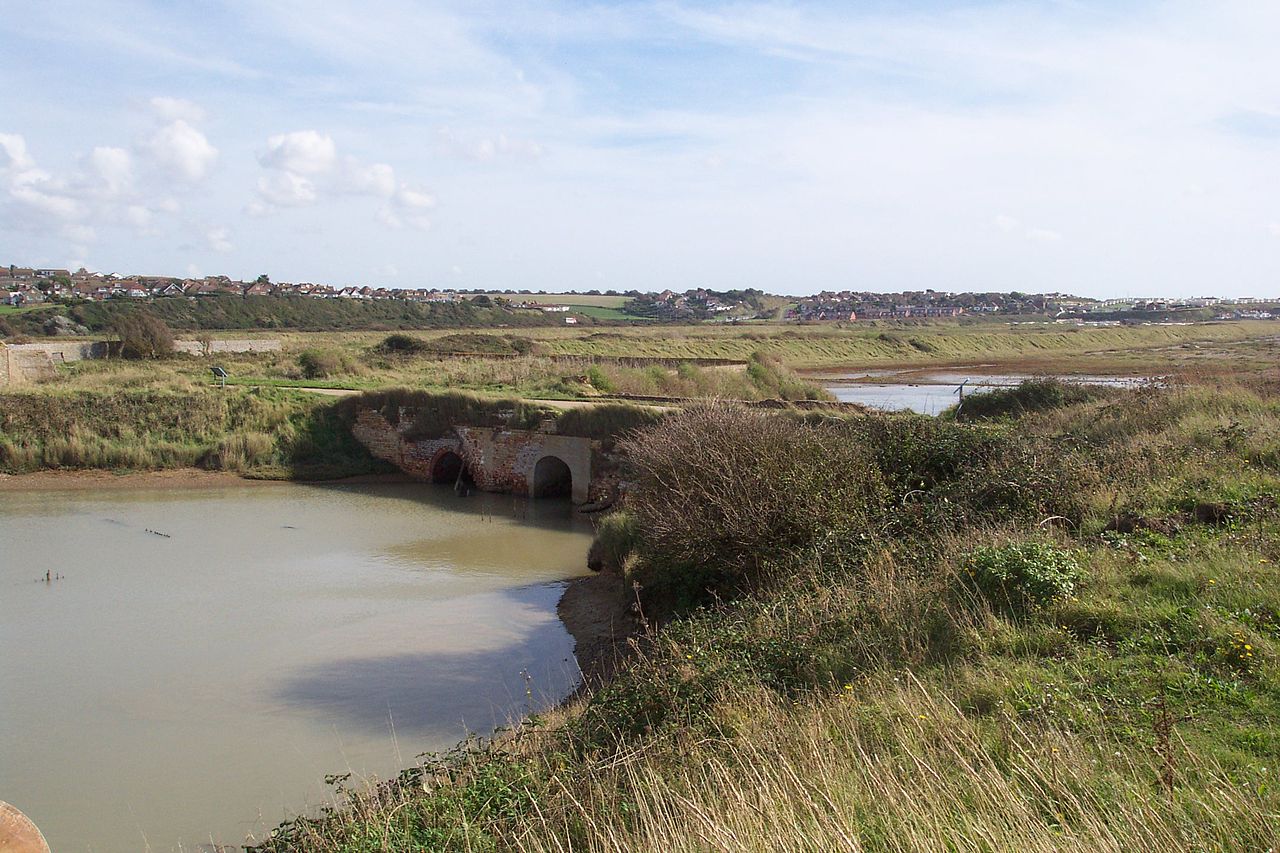
The
Tide Mills at Newhaven, looking from the Channel to Bishopstone
THE PORT
Although there are some signs of the derelict facilities that serviced the former train ferry operations, the port still sees a great deal of freight and passengers movement. International ferries run to the French port of Dieppe, Seine-Maritime, operated by DFDS Seaways. There are two outbound sailings per day, one in the morning and one in the evening, using the 18,654 GT ro-ro ferry MS Côte D'Albâtre. Rail passengers wishing to connect with the ferries are advised nationally to travel to Newhaven Town, and then use the free bus service; this has resulted in a dramatic fall in passenger services at Newhaven Harbour, leading to questions regarding its future and that of Newhaven Marine.
The port is the proposed main landside site for E.ON's development of the offshore-Rampion Wind Farm.
LIFEBOATS
The Newhaven Lifeboat, the first of which was commissioned in 1803, is among the oldest in Britain, and was established some 20 years before the Royal National Lifeboat Institution. The town established the rescue lifeboat in response to the wreck of HMS Brazen in January 1800, from which only one man of her crew of some 105 men could be saved. The town used a combination of funds raised locally and contributed by Lloyd's of London to purchase a lifeboat built to Henry Greathead's "Original" design. Newhaven also has one of the Watch stations of the National Coastwatch Institution.
MILITARY
Newhaven Fort, one of the Palmerston Forts, was built on Castle Hill on the recommendation of the 1859 Royal Commission to defend the growing harbour. It was the largest defence work ever built in Sussex and is now open as a museum.
The adjacent village of Tide Mills was the site of an experimental seaplane base at the head of the beach. The first formation of No. 242 Squadron RAF was on 15 August 1918 from numbers 408, 409 and 514 Flights at the seaplane station at Newhaven, Sussex. Operating from there and the nearby airfield at Telscombe Cliffs, it was equipped with Short Type 184 seaplanes and carried out anti-submarine patrols over the English Channel until the end of the First World War. Surveys carried out in 2006 have exposed part of the slipway, concrete aprons to both hangars with door tracks and several other slabs presumed to be workshops. Sussex Archaeological Society started a dig in April 2006 to catalogue the entire East Beach site.
LANDMARKS
The main landmark in the town is the Newhaven Fort. The new waste incinerator is a major landmark, the chimney being visible from the sea as well as from Firle Beacon and parts of Seaford.
The parish includes part of the Brighton to Newhaven Cliffs Site of Special Scientific Interest. The cliffs are mainly of geological interest, containing many Santonian and Campanian fossils. The SSSI listing includes flora and fauna biological interest too.
The open land surrounding Newhaven to the west, north and east is part of the South Downs National Park, although the town itself is excluded from the boundaries.
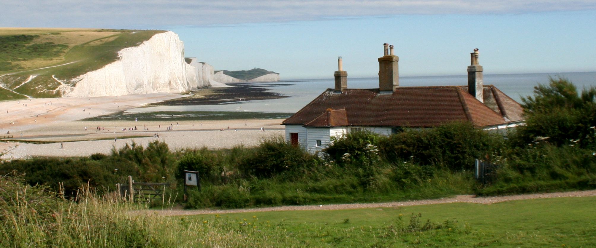
The coastguard cottages at Seaford Head
SOUTH
DOWNS KEY FACTS
The South Downs National Park is the newest of the UK’s 15 National Parks.
It officially came into being on 31 March 2010. Yet, the idea of a National Park in the South Downs can be traced all the way back to 1929.
In 2016 the National Park was granted International Dark Sky Reserve status, making it one of the best places in the country to view the night sky. Today,
the area is one of only 16 such Reserves in the world. The South Downs Way is one of 15 National Trails. However, it is the only National Trail to lie entirely within a National Park.
The National Park is home to a number of globally important habitats, including lowland heath, described as rarer than rainforest.
Woolmer Forest, a lowland heath site, is the only place in the country to have all 12 of the UK’s native amphibian and reptile species.
Around 4% of the land in the National Park is chalk grassland. Since the
Second World
War, the UK has lost over 80% of its chalk grassland.
The South Downs is home to a number of rare species, including the Adonis blue butterfly that thrives in chalk grassland.
It is thought that the chalk ridgeline of the South Downs Way has been used by people for more than 6000 years.
Cissbury Ring, just north of Worthing, is the second largest hillfort in England. It is a Scheduled monument due to its Neolithic flint mines and the remnants of the Iron Age fort.
The South Downs is the most populous of the UK’s National Park. 117,000 live and work within the Park’s boundaries with an additional 2 million people living within 5km of the Park.
The
beaches along the coast of the South Downs National Park, are littered
with plastic waste, that is left by visitors, or blown up onto the
shore with the tide. Many local groups organise beach cleaning parties
on a regular basis, but cannot keep up with the flow of plastic that is
being dumped into the sea from rivers
all over the world that are unregulated.